tool · draft
kepler.gl
Open-source geospatial analysis tool for large datasets that runs in a browser: load a file, add layers, filter and animate over time, without writing code.
What is reusable: open sourceunknown dataAPI unknownopen participation MIT
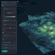
kepler.gl describes itself on GitHub as an open source geospatial analysis tool for large-scale data sets. The repository, keplergl/kepler.gl, is under the MIT licence and tags itself with data visualisation, geospatial and Mapbox.
It is on this shelf for the person who has a table of coordinates from a model or a sensor network and no developer: the application runs in a browser and takes a file. A fuller description waits on a page that can be read; the home page is a script-only shell.
- form
- open-source browser application
- group
- 3D cities and mapping
- homepage
- https://kepler.gl/
- licence
- MIT
- cost
- free
alternative to
-
Free, open-source GIS from the opengeos project that loads, styles and analyses geospatial data in a web browser, as a desktop or phone app, or inside a Jupyter notebook, keeping the data on the user's own machine.
open sourceAPIopen participation
Tags: visualization, web, no code, large datasets, open source, try in a browser