data source · draft
GEBCO global bathymetry grid
Free global map of the depth of the seafloor, with land heights, on a 15 arc-second grid, released once a year by the General Bathymetric Chart of the Oceans and the Seabed 2030 project.
What is reusable: unknown sourceopen dataAPI unknownopen participation public domain, free of charge, with attribution requestedGEBCO takes contributed survey data, soundings and grids to improve the grid.
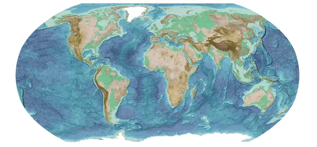
The GEBCO_2026 Grid, ice surface elevation, Robinson projection. GEBCO Compilation Group (2026), public domain with attribution.
GEBCO (the General Bathymetric Chart of the Oceans) is a non-profit body working under the International Hydrographic Organization and UNESCO's Intergovernmental Oceanographic Commission.4 Its chart series began in 1903.4 It relies largely on volunteer geoscientists and hydrographers.4 Bathymetry is the measurement of the depth and shape of the seafloor.4 The Nippon Foundation of Japan proposed a partnership with GEBCO in 2016 to map the whole ocean floor by 2030, and the two now run it as the Seabed 2030 project.2,4
The GEBCO Grid is a single terrain model of ocean and land, with heights and depths in metres on a 15 arc-second grid of 43,200 rows by 86,400 columns.1,2 The current grid, GEBCO_2026, was published in April 2026.2 It is built on the SRTM15+ dataset from Scripps Institution of Oceanography, which joins land heights with measured seafloor depths and depths predicted from satellite measurements of gravity.2,3 Grids compiled from survey data, mostly multibeam sonar, by four Seabed 2030 regional centres are blended onto that base.2,3 North of 60°N and south of 60°S the land and ice heights come from BedMachine models of Greenland and Antarctica and other polar sources.2 One version gives the ice surface and a second gives the ground beneath the ice.1,2
Alongside the depths comes a Type Identifier grid that says, cell by cell, what each value rests on: a direct measurement such as multibeam, singlebeam or lidar, an indirect one such as a gravity prediction or interpolation, or an unknown source.2,3 GEBCO notes that the data are assumed to be relative to mean sea level, but some shallow-water sources use other vertical datums.1,2
The grid is in the public domain and free, including for commercial use, and GEBCO asks that it be credited with a citation that carries its DOI.1,2 It can be downloaded whole as netCDF or in eight tiles as GeoTIFF or Esri ASCII raster; the global netCDF file is 7 GB uncompressed.1,2 A download app cuts out a chosen area, and the grids can also be read over OPeNDAP, a protocol for reading parts of remote files, through the UK's Centre for Environmental Data Analysis.1 GEBCO takes contributions of singlebeam and multibeam survey data, individual soundings and existing grids to improve the grid.4
GEBCO lists what seafloor depth is used for: ocean circulation, tides, tsunami forecasting, fishing, sediment transport, geo-hazards, and routing cables and pipelines.4 For someone modelling a coast, a bay or a stretch of sea, it supplies the depths a tide, wave or circulation model needs as its floor.4 The Type Identifier grid shows where those depths were surveyed and where they were estimated.2,3
- coverage
- global, ocean and land; a version with the ground under the ice of Greenland and Antarctica
- resolution
- 15 arc-seconds (43,200 by 86,400 cells); a test multi-resolution product where finer data exist
- cadence
- a new global grid each year; GEBCO_2026 published April 2026
- access
- global downloads, a download app for chosen areas, OPeNDAP through CEDA, and web map services; no registration stated
- format
- netCDF, GeoTIFF, Esri ASCII raster
- homepage
- https://www.gebco.net/data-products/gridded-bathymetry-data
does a similar job
-
The European Union's global elevation model from the TanDEM-X radar mission, a surface model of the land including buildings and trees, free worldwide at 30 m (GLO-30) and 90 m (GLO-90).
open dataAPI
alternative to
-
The European Union's global elevation model from the TanDEM-X radar mission, a surface model of the land including buildings and trees, free worldwide at 30 m (GLO-30) and 90 m (GLO-90).
open dataAPI
Tags: bathymetry, seafloor, ocean depth, elevation, terrain, raster