tool · draft
DeepReefMap
Open-source pipeline from EPFL's ECEO lab that builds labelled 3D point clouds, orthomosaics and benthic cover statistics of coral reefs from handheld underwater video.
What is reusable: open sourceunknown dataAPI unknownunknown participation Apache 2.0

Hugues Sibille (EPFL) and Jonathan Sauder (MIT and EPFL) maintain DeepReefMap under EPFL's ECEO group.1 The method, for rapid 3D semantic mapping of reefs, was published in Methods in Ecology and Evolution in 2024.1 From one video it produces a semantic 3D point cloud, an orthomosaic, per-class benthic cover statistics and an interactive viewer.1 A semantic point cloud is a set of 3D points, each labelled with what it shows. An orthomosaic is a single map-like image stitched from many frames. Benthic cover is the share of the seabed each class occupies.
The pipeline rectifies frames with a camera profile, segments each frame (labels every pixel by class), reconstructs depth and camera pose, then exports the products.1 It ships with profiles for the GoPro Hero 10 and 12.1 Other cameras are calibrated with a built-in tool based on COLMAP, an open-source photogrammetry program.1 Several reconstruction backends can be chosen. A basic one runs on CPU, higher-quality ones need a GPU (NVIDIA, AMD or, for some, Apple Silicon), and one has gated weights limited to non-commercial research use.1 Segmentation defaults to a model trained on CoralscapesV2, a panoptic reef dataset of 2,433 annotated images from 55 Red Sea sites with 95 classes, released under Apache 2.0.1,2 A panoptic dataset labels both individual objects and background regions.
DeepReefMap is a command-line tool in Python 3.10 to 3.12, licensed Apache 2.0.1 A GPU is strongly recommended, and a separate desktop app exists.1 Bundled third-party components and downloaded checkpoints have their own terms.1 The project is public and actively developed, with workshop papers cited for 2025 and 2026, and its latest tagged release, v1.2.0, came out in October 2026.1,3
- form
- open-source pipeline
- group
- 3D capture and reconstruction
- homepage
- https://github.com/eceo-epfl/deepreefmap
- licence
- Apache 2.0
- cost
- free
requires this data or input
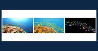
Densely annotated Red Sea coral reef image datasets from EPFL and partners for training segmentation models; V2 adds panoptic labels, 95 classes and fish instances; training data behind DeepReefMap.
open data
uses this engine, platform or technique

Feed-forward 3D vision model from Meta AI and Oxford's Visual Geometry Group that predicts camera poses, depth and point clouds from video; used as a reconstruction backend in DeepReefMap for coral reef mapping.
partly open source

Open-source streaming 3D reconstruction model from the Robbyant team at Ant Group that estimates camera poses, depth and point clouds from a video or image sequence in one feed-forward pass.
open source
Tags: coral, reef, 3d reconstruction, segmentation, underwater, video