
Fire
Fire: wildfire risk, spread and the exposure of people and places.
tools
-
Two commercial climate-risk platforms: Climate X's Spectra turns physical climate hazards into asset-level financial loss figures worldwide; UrbanFootprint's Resilience Insights combine hazard, community and land-use data for any location in the United States.
Fire closed sourceclosed dataAPI

Open-source Python library by James Adams that computes drought, fire and flood-potential indices such as SPI, SPEI, the Palmer family and KBDI from station or gridded precipitation and temperature.
Weather & climateWaterFire open source
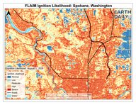
EarthDaily's wildfire risk model, which combines satellite observations, daily weather and other geospatial data into ignition likelihood, fuel hazard and directional vulnerability layers, sold to insurers in the western United States.
Fire closed sourceclosed data

Wildfire risk platform from Opal AI Inc. of Marina del Rey, California, that combines imagery, lidar, GIS, weather and field data into risk rankings and mitigation recommendations for utilities, fire agencies and insurers.
Fire closed source

Technosylva makes wildfire and extreme-weather risk software for electric utilities and fire agencies, modelling fire behaviour against weather, fuels, terrain and assets.
Fire closed source
data sources
-
Lidar-derived model from CTrees of forest fire fuels as one-metre voxels carrying canopy, ladder and ground fuel properties, demonstrated at three US sites and published as open 3D arrays for fire models to read.
FireLiving systems open data
articles
-
Annual update of sixteen planetary vital signs by William Ripple, Christopher Wolf and colleagues in BioScience; in 2026 seven of the sixteen are at record extremes.
questions
-
Where might a fire spread from here, what is exposed, and where would clearing, burning or hardening help most?
Symbol: "Fire" by Gregor Cresnar, Noun Project, CC BY 3.0.